


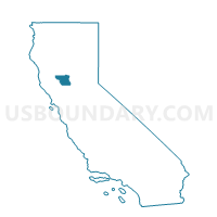
Voting District 29015, Colusa County, California
About
Outline

Summary
| Unique Area Identifier | 529119 |
| Name | Voting District 29015 |
| County | Colusa County |
| State | California |
| Area (square miles) | 77.75 |
| Land Area (square miles) | 77.32 |
| Water Area (square miles) | 0.43 |
| % of Land Area | 99.44 |
| % of Water Area | 0.56 |
| Latitude of the Internal Point | 39.03305780 |
| Longtitude of the Internal Point | -121.89571810 |
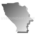
Maps


Graphs
Select a template below for downloading or customizing gragh for Voting District 29015, Colusa County, California


Neighbors
Neighoring Voting District (by Name) Neighboring Voting District on the Map
- Voting District 19000, Colusa County, CA
- Voting District 29010, Colusa County, CA
- Voting District 30055, Sutter County, CA
- Voting District 39031, Colusa County, CA
- Voting District 39035, Colusa County, CA
- Voting District 50150, Sutter County, CA
- Voting District 50335, Yolo County, CA
Top 10 Neighboring County Subdivision (by Population) Neighboring County Subdivision on the Map
- Central Colusa CCD, Colusa County, CA (11,838)
- East Colusa CCD, Colusa County, CA (8,798)
- Knights Landing CCD, Yolo County, CA (4,193)
- Meridian-Robbins CCD, Sutter County, CA (1,561)
Top 10 Neighboring Place (by Population) Neighboring Place on the Map
Top 10 Neighboring Elementary School District (by Population) Neighboring Elementary School District on the Map
Top 10 Neighboring Secondary School District (by Population) Neighboring Secondary School District on the Map
Top 10 Neighboring Unified School District (by Population) Neighboring Unified School District on the Map
Top 10 Neighboring State Legislative District Lower Chamber (by Population) Neighboring State Legislative District Lower Chamber on the Map
Top 10 Neighboring State Legislative District Upper Chamber (by Population) Neighboring State Legislative District Upper Chamber on the Map
Top 10 Neighboring 111th Congressional District (by Population) Neighboring 111th Congressional District on the Map
Top 10 Neighboring Census Tract (by Population) Neighboring Census Tract on the Map
- Census Tract 1, Colusa County, CA (5,183)
- Census Tract 114, Yolo County, CA (4,193)
- Census Tract 509, Sutter County, CA (1,561)